Showing posts with label place. Show all posts

The Chapel Inside a Volcano


Santa Margarida is a freato-magmatic volcano located in the Spanish county of Garrotxa, in Catalonia. Some 11,500 years ago, the earth’s crust burst opened and out poured millions of tons of magma, that accumulated in a conical hill more than six hundred meters tall. At the top of this hill a wide circular crater was formed, whose floor today is carpeted with thick grass and shrubs while the flanks of the volcano are covered in evergreen holm oak and mixed deciduous forest. Amidst this, and smack in the middle of the crater today, stands a Romanesque church.
Not much is known about the hermitage of Santa Margarida, after which the volcano was named, except that the building was destroyed during the 1428 Catalonia earthquake, suggesting it was first built at least 600 years ago. The current building is from 1865.
santa-margarida-volcano-1

Exercise Tiger: The Disastrous D-Day Rehearsal That Cost 800 Lives


In the early morning hours of June 6, 1944, thousands of Allied soldiers stormed into the beaches of northern France in what became the largest seaborne invasion in history. In the space of a single day, Operation Overlord put over 180,000 troops ashore in Normandy, creating a beachhead that eventually allowed more than 3 million Allied soldiers into German occupied Western Europe, setting the stage for the final phase of the war in Europe.

In the months leading up to D-Day, the Allied powers organized a series of training exercises involving full dress rehearsal and live ammunition in order to give the soldiers a small taste of what they would experience during the actual landings. One such rehearsal took place in a small sleepy Devon village named Slapton.
exercise-tiger-1
American troops landing on Slapton Sands in England during rehearsals for the invasion of Normandy.
Slapton was located on the southwest coast of England where it meets the English Channel. It was chosen because Slapton’s beach looked very similar to the one in Cotentin Peninsula, the westernmost of the five beaches along Normandy where the real assault would take place. This particular beach was code named Utah.

Makhunik: The Village of Dwarves

Makhunik: The Village of Dwarves
In a remote corner in Iran’s South Khorasan Province, near its border with Afghanistan, is a village that, until about a century ago, was inhabited by people of very short stature. Indication of their dwarfism is found in the local architecture. Of the roughly two hundred stone and clay houses that make up the ancient village, seventy or eighty of them are of exceptionally low height. These adobe dwellings are less than two meters tall with narrow doorways that cannot be entered without stooping. Some of these houses have ceiling as low as 140 cm.
Marriages between close relatives, poor diet and drinking water laced with mercury had left the residents of Makhunik a good half a meter short than the average height of that time.
makhunik-dwarf-village-8

The Soccer Stadium Lying On Two Hemispheres


This Friday, two local Brazilian football clubs—Santos FC and Macapá—will face each other at the Estádio Milton Corrêa, a multi-purpose stadium in the city of Macapá, Brazil. When the whistle blows at 5:00 PM local time, each team will defend the goal on their side. But that’s not the only thing they will be defending.
soccer

Estádio Milton Corrêa is the most centrally located stadium anywhere in the world. It straddles right over the equator. In fact, it’s so precisely built that the mid-field line coincides exactly with the equator line, so that each half of the field lies on a different hemisphere. In every soccer game that’s played here, each team isn't just defending its own goal. One side is defending the northern hemisphere, and the other side the southern hemisphere.

China’s Bicycle Graveyards

China’s Bicycle Graveyards
Over the last few years, the bicycle-sharing phenomenon has taken the world by storm, especially in China, where—according to one report—there are over 70 private bike-sharing companies in operation with a collective pool of 16 million cycles and over 130 million users. These bikes, especially the dockless variety, can be picked up from anywhere on the streets using a smartphone to unlock them first, and then dropped off anywhere without the need to park it at a dock. Regular users say these bikes are godsend because it allows them to avoid congested public transport routes and reduce travel costs, while also reducing pollution and encouraging users to stay fit.
However, the supply has vastly outpaced demand. Many Chinese cities ill-equipped to handle the sudden flood of millions of shared bicycles have been overwhelmed. Illegal parking have led to clogged sidewalks, while damaged and mangled bikes are routine occurrence.
bike-sharing-graveyard-china-2

Peary Land, The Land of Extremities


The northern tip of Greenland, despite being situated a little over 700 km from the north pole, is entirely ice free and has been for the last 8,000 years since the glaciers retreated. It is the most northerly ice-free region in the world. The climate is high arctic with a relatively warm summer of less than two months and long winters. Precipitation levels are so low that this region has been dubbed a ‘polar desert’.
This region, a peninsula, is called Peary Land—named in honor of Robert Peary, who first explored it during his expedition of 1891 to 1892.
peary-land

The Theater That Shakespeare Stole


On a cold, snowy December night in 1598, about a dozen men armed with swords, daggers and axes quietly broke into a recently vacated theater in Shoreditch, located just outside the city of London. With the aid of what modest light their lanterns could throw, the men worked tirelessly all throughout the night, dismantling the theater beam by beam and nail by nail, and loading the stripped timber onto wagons. By the time the darkness of the night gave way to the first light of dawn, the theater was gone.
The vandals in question were the Lord Chamberlain's Men, the theatrical troupe to which William Shakespeare belonged. For the past several years, the Chamberlain's Men had been playing at Shoreditch’s Theatre. This theater, built in 1576, was the second permanent theater ever built in England, and the first successful one to be built for the sole purpose of theatrical productions.
shakespeares-globe-7

The Ice Caves That Never Melt, Even In Summer


In the mountains of the Shanxi province in China, is the country’s biggest ice cave—an 85-meter deep bowling pin shaped subterranean structure set into the side of the mountain. Its walls and floors are coated with thick layers of ice, while large icicles and stalactites stretch from the ceiling to floor. The Ningwu Cave has the unique ability to stay frozen throughout summer even when the outside temperature climbs into the high teens.
Across continental Europe, Central Asia, and North America are many such ice caves where winter lasts all round the year. The majority of these ice caves are located in cooler regions, such as Alaska, Iceland and Russia, where the year-long low temperature helps keep the caves naturally cool and frozen. However, ice caves also exist in warmer climates.
ningwu-ice-cave-6

The Ruins of Suakin Island


The island town of Suakin, in north-eastern Sudan, was an important port for trade and culture on the East African coast for centuries. The town is located on a flat, oval-shaped island, on the west coast of the Red Sea, inside a narrow inlet that penetrates four kilometer inland and ends in a wide basin about two kilometers across. There are two round coral islands in the shallow basin. One of the islands is deserted and contains nothing but a cemetery. The other island to the south is the site of Suakin. The island is connected to the mainland by a short man-made causeway.

Once the principal port of Sudan, Suakin lost its importance when a new har­bor, Port Sudan, was built to the north in the beginning of the 20th century. Over the course of the century, Suakin slowly began to lose its population until it had turned into a ghost town.

suakin-11

Moroccan Wall: The Longest Minefield in The World

Moroccan Wall: The Longest Minefield in The World


You may or you may not have heard about “Western Sahara”, but if you consult Google Maps or any other modern atlas, you will notice this region clearly identified in the southern end of Morocco. “Western Sahara” is not an actual country, as indicated by the lack of a political boundary between this region and Morocco, but it isn’t totally under the control of Morocco either. It is a disputed region with a complex, war-torn history, and like many other disputed regions in the world, it has a highly militarized zone at the center of which runs a 2,700 km-long sand wall called the Moroccan Western Sahara Wall, or the Moroccan Wall, in short.
Unlike other notorious barriers in the world, the Moroccan Wall is rarely in the news and is little discussed outside of Africa. The existence of this wall has been buried in the desert, along with the 40-year-old plight of the Sahrawi people the Moroccan Wall has kept divided.
moroccan-wall-7

Super Mario fans, rejoice! A new bar just opened in Washington D.C.

Super Mario fans, rejoice! A new bar just opened in Washington D.C.


Called The Cherry Blossom Pub, the pop-up bar has been put together by The Drink Company. “Japan has always been a source of inspiration for me and, as a native Washingtonian, cherry blossom season is something we look forward to every year,” Derek Brown of Drink Company said. “This pop-up brings together some of my favorite things under one roof, including both classic cocktails and Mario nostalgia.” Once you step inside the bar, you can expect to be feeling nostalgic right away… Think 8-bit question blocks, mushrooms hanging from the ceiling, cocktails called ‘It’s A Me, A Mario’, and even the bartenders are dressed as Mario and Luigi! Check out the pics below.
More info: cherryblossompub.com (h/t)

Agloe: A Fake Town That Became Real

Agloe: A Fake Town That Became Real


In the 1930s, a small town named Agloe suddenly began appearing on the maps of New York. It was positioned near an unmarked dirt road that led from Roscoe to Rockland, and near to Beaverkill. That road was neither visited by anyone nor was it popularly known, and very few people, if any, outside of the mapmakers’ company, knew that the town of Agloe didn’t even exist.

Agloe was a copyright trap—a century old trick mapmakers and dictionary makers have been using to catch copycats. When companies create a map, they perform all the hard work on it, including examining the right spellings, placing the cities in the right spot on the map, etc., and they need to protect their work. So they add small traps to the map—a fake street, a fantasy town. When another company steals their map, the original creators are able to take their competitors to court by pointing out the fake places that shouldn’t be on the map.
agloe-ny-2

The Basement Shops Bulgarian capital of Sofia


Street vendors are a common sight in cities across the world. The inability to pay high rent, or the unavailability of cheap commercial space, have pushed these small merchants on to streets, and in some cases, on to basements, as in the Bulgarian capital of Sofia.
Known as klek shops, these basement shops are unique to the city of Sofia. The shops are set in the basement of the buildings containing a small window that opens in the sidewalk, usually below the knee level. This is why they are known as “klek shops”—klek means knee. Products are displayed outside on the sidewalk, but to order something, customers need to squat and peer into the window and into the dimly lit face of the trader inside the basement.
klek-shops-bulgaria-2

The Dust Bowl of The 1930s


The 1930s were some of the driest years in American history. Eight long years of drought, preceded by inappropriate cultivation technique, and the financial crises of the Great Depression forced many farmers off the land abandoning their fields throughout the Great Plains that run across the heart of mainland United States. When the high winds came, it lifted the topsoil from barren lands and carried them in large choking clouds of dust for thousands of miles. Many dust storms started around the panhandles of Texas and Oklahoma and touched adjacent sections of New Mexico, Colorado, and Kansas. But eventually the entire country was affected forcing tens of thousands of families to abandon their farms and migrate in search for work and better living conditions.
dust-bowl-7
A dust storm approaches Stratford, Texas, in 1935. Photo credit: George E. Marsh
The early European explorers thought the Great Plains was unsuitable for agriculture. The land is semi-arid and is prone to extended drought, alternating with periods of unusual wetness. But the federal government was eager to see the land settled and cultivated. After the end of the Civil War in 1865, a series of federal land acts were passed granting settlers hundreds of acres of land. These acts led to a massive influx of new and inexperienced farmers across the Great Plains.
A stretch of unusually wet weather in the beginning of the 20th century confirmed the belief that the Plains could be tamed after all, leading to increased settlement and cultivation. Farmers ploughed through the land eliminating the native grasses that held the fine soil in place. When crops began to fail with the onset of drought in 1930, the bare soil became exposed to the wind, and it began to blow away in massive dust storms that blackened the sky.
These choking billows of dust, named "black blizzards", traveled across the country, reaching as far as the East Coast and striking such cities as New York City and Washington, D.C.
"The impact is like a shovelful of fine sand flung against the face," Avis D. Carlson wrote in a New Republic article. "People caught in their own yards grope for the doorstep. Cars come to a standstill, for no light in the world can penetrate that swirling murk... We live with the dust, eat it, sleep with it, watch it strip us of possessions and the hope of possessions. It is becoming Real."
The term “dust bowl” was coined by Edward Stanley, Kansas City news editor of the Associated Press. Originally it referred to the geographical area affected by the dust, but today the entire event is referred to as the Dust Bowl.
After the winds passed and the dust settled, President Franklin Roosevelt initiated a huge project to plant hundreds of millions of trees across the Great Plains to create a giant windbreak. Known as a shelterbelt, it consisted of 220 million trees stretching in a 100-mile wide zone from Canada to northern Texas, to protect the land from wind erosion. The shelterbelt wasn’t a continuous wall of trees, but rather short stretches protecting individual farmlands. By 1942, there was more than thirty thousand shelterbelts across the Plains. To this day it remains the largest and most-focused effort of the US government to address an environmental problem.
Now many of the shelterbelts are either gone or no longer provide the benefits that they used to. The trees that were once essential have now become a burden to the farmers whose focus is now to put more land into production. Some fear that the loss of these trees might lead to another crippling dust storm in the future.
dust-bowl-1
Buried machinery in a barn lot; Dallas, South Dakota, May 1936.
dust-bowl-2
A farmer and his two sons during a dust storm in Cimarron County, Oklahoma, April 1936. Photo credit: Arthur Rothstein.
dust-bowl-5
dust-bowl-6
dust-bowl-8
The huge Black Sunday storm strikes the Church of Good in Ulysses, Kansas, 1935. Photo credit: Historic Adobe Museum
dust-bowl-9
dust-bowl-10
The huge Black Sunday storm as it approaches Ulysses, Kansas, April 14, 1935. Photo credit: Historic Adobe Museum, Ulysses, KS
dust-bowl-12
Migrant agricultural worker's family. Seven hungry children. Mother aged thirty-two. Father is a native Californian. Destitute in pea picker's camp, Nipomo, California, because of the failure of the early pea crop. These people had just sold their tent in order to buy food. Of the twenty-five hundred people in this camp most of them were destitute, March 1936. (Dorthea Lange/Library of Congress/LC-USF34-T01-009093)
One of the most famous photograph of the Depression and the Dust Bowl, The Migrant Mother, by Dorthea Lange
dust-bowl-3
A migratory family from Texas living in a trailer in an Arizona cotton field. Photo credit: Dorothea Lange
dust-bowl-16
Three children prepare to leave for school wearing goggles and homemade dust masks to protect them from the dust. Lakin, Kansas, 1935. Photo credit: Green Family Collection
dust-bowl-4
An abandoned Dust Bowl ghost town in South Dakota. Photo credit: Paul Williams/Flickr
Dust Bowl Ghost Town
An abandoned Dust Bowl ghost town in South Dakota. Photo credit: Paul Williams/Flickr
shelterbelt
Sign for "Nation's First Shelterbelt" located near Willow. Photo credit: Newsok.com
Sources: Wikipedia / America's Library / Living History Farm / NPR / Wikipedia

Herculaneum: Pompeii’s Less Famous Neighbor


In late August 79 AD, Mount Vesuvius blew its top off and for three days death rained down upon towns, villas and farms surrounding the volcano. One of the most famous casualties of the eruption was the Roman town of Pompeii, known for its wealthy inhabitants and lavishly decorated homes. The other was Herculaneum, an equally wealthy but smaller seaside resort and trading port. The larger Pompeii, glamourized with its brothels, bars, and amphitheatre, has completely overshadow Herculaneum and many other towns that suffered the same fate. Herculaneum, in particular, is worth visiting because its ruins are far better preserved than Pompeii’s.
herculaneum-7
The ruins of Herculaneum. Notice the depth the city is buried. These are boat houses that once lined the ancient shore. Photo credit: Dave & Margie Hill/Flickr
Herculaneum was located much closer to the crater, than Pompeii was. Despite this, Herculaneum escaped the initial onslaught of raining tephra because it was situated in the opposite direction the wind was blowing. So while the wind was carrying the deadly cloud of gas and ash towards the neighboring town of Pompeii, where it slowly suffocated the hapless citizens, many of Herculaneum’s residents were gathering their belongings and preparing to flee.
The following night, Vesuvius unleashed its fury on the now mostly evacuated town of Herculaneum. A succession of six pyroclastic flows and surges buried the city's buildings, knocking down walls, tearing away columns and other large objects. Other areas were simply engulfed by ash and hot gases and saw little damage. These areas had the best preserved structures. When Herculaneum was partially excavated in the early 18th century, archeologists discovered intact buildings, wooden furniture and carbonized organic matter such as fruit, bread and even the contents of sewer. They also unearthed some 300 skeletons establishing that the town was not completely evacuated as previously thought. Unlike Pompeii, most of the town of Herculaneum is yet to be excavated.
Herculaneum is much easier to explore than Pompeii because it is smaller in size and there are far less tourists in Herculaneum than in Pompeii. The most noteworthy building in Herculaneum is a luxurious villa called the "Villa of the Papyri." The villa is thought to have belonged to Lucius Calpurnius Piso Caesoninus, Julius Caesar's father-in-law, although later research have thrown some doubt on the identity of the villa’s owner. The villa stretches down towards the sea in four terraces, and has a fine library, the only one to survive intact from antiquity.
herculaneum-12
A map showing the cities and towns affected by the eruption of Mount Vesuvius in 79 AD. The general shape of the ash and cinder fall is shown by the dark area to the southeast of Mt Vesuvius. Image credit: MapMaster/Wikimedia
herculaneum-1
Photo credit: Rita Willaert/Flickr
herculaneum-3
Photo credit: Greg Willis/Flickr
herculaneum-4
Photo credit: Greg Willis/Flickr
herculaneum-5
Photo credit: Greg Willis/Flickr
herculaneum-6
Photo credit: Andrea Hale/Flickr
herculaneum-2
Photo credit: Rita Willaert/Flickr
herculaneum-10
Photo credit: Simon/Flickr
herculaneum-9
Photo credit: Mark Garth/Flickr
herculaneum-14
Photo credit: Xtreambar/Wikimedia
Subscribe to our Newsletter and get articles like this delivered straight to your inbox

Who Put Bella In The Wych Elm


This question, which appears in the form of a graffiti on a towering brick obelisk in Hagley in Worcestershire, England, has been haunting the small village for more than seventy years.
The story begins one April afternoon in 1943. Four teenage boys from a neighboring village were out hunting for bird eggs in Hagley Wood when they came across a large wych elm. In the hollow trunk of the elm they discovered what first appeared to be an animal skull. But after seeing hair and teeth, the horrified boys realized that it was human. Knowing the boys were trespassing on another’s property, they quietly put the skull back into the hollow and made a pact to tell no one about the grisly find. But the weight of the secret was too much to bear for the youngest of the boys, Tommy Willetts, who told his parents, who in turn notified the police.
bella-wych-elm-1
Photo credit: David Buttery/Wikimedia
When the police checked the trunk of the tree they found not only the detached skull but an almost complete skeleton, with a shoe, a gold wedding ring, and some fragments of clothing. A severed hand from the body was also discovered buried nearby. Forensics determined that it was the skeleton of a woman, around 35 years of age, and she had been dead for at least 18 months. A fragment of taffeta in her mouth established the cause of death as suffocation. The coroner declared that the woman was murdered and her body pushed into the hole while she was still warm, as rigor mortis would have made it impossible to fit the body into the tight confines of the hollow trunk.
Despite exhaustive searches through dental records, the police could not identify the victim. The Second World War, which was in full swing at that time, also hampered investigation as a lot of men and women had gone to the war or relocated somewhere else and were reported missing. The trail eventually grew cold.
Bella_Skull
The skull of "Wych Elm Bella," as retrieved 18 April 1943.
That Christmas mysterious graffiti began appearing around town asking the ominous question: “Who put Luebella down the wych elm?”, or the variation, “Who put Bella in the Wych Elm?”. The messages were written in chalk in three-inch-tall capital letters, probably by the same hand.
This was the first time the victim was called by a name, implicating that the artist knew who the victim was and possibly the murderer too. Or perhaps the mysterious graffiti artist was the killer himself (or herself), mocking and taunting the police with his messages. Whoever the artist was, the person never came forward, but the messages continued to appear, and have so, intermittently up until the present times.
Whether or not “Bella” was the victim’s real name became irrelevant. The name stuck and even the police began to use it. Initially, investigation tracked down a Birmingham-based prostitute named Bella, who reportedly went missing in 1941, but results were inconclusive.
Thanks to the persistent graffiti, the murder mystery refused to die and as the decades rolled by, new theories emerged. An anthropologist named Margaret Murray was certain the case was tied to witchcraft. Cutting off the hand and imprisoning the body in the hollow of a tree was an ancient tradition, she pointed out. Another theory identified the killed woman as a Dutch spy named Clarabella Dronkers (notice the “bella” in her name?) who was passing information to the Nazis and was executed by her fellow Dutchmen for treason.
Periodically, memories of the macabre murder would be revived by a fresh graffiti. Since at least the 1970s, this graffiti has adorned the walls of the 18th century Wychbury Obelisk in Hagley Park. Sometimes the paint on the graffiti would fade away but there was always someone in town who wanted to keep the mystery alive, and a new graffiti would appear.
Even the police haven’t lost hope. As of 1999, more than half a century after the body was discovered, the case file was still open and the West Mercia police still waiting for new leads. But with most of the witnesses dead, it’s unlikely that any new leads will be coming. The true identity of Bella will perhaps never be found.
bella-wych-elm-2
Photo credit: A Sibs Oddity/Flickr
hagley-monument
The Hagley Monument where the graffiti is painted. Photo credit: Tony Hisgett/Wikimedia
Sources: www.news.com.au / Brian Haughton / BBC / Wikipedia
Subscribe to our Newsletter and get articles like this delivered straight to your inbox

Paracas Candelabra of Peru


The Nazca Lines in southern Peru are some of the best known geoglyphs on earth, but they aren’t the only ones in the Nazca desert. About 200 kilometers north west of Nazca is another isolated and somewhat less popular geoglyph called Paracas Candelabra. It is also known as the “Candelabra of the Andes” because of its resemblance to a three-branched candlestick.
The geoglyph is etched on the sloping face of a hill at Pisco Bay on the Peruvian coast. The design has been cut into the soil to a depth of two feet with stones, possibly from a later date, placed around it. The figure is 181 meters tall, large enough to be seen as far as twenty kilometers out at sea.
paracas-candelabra-2
Photo credit: Unukorno/Wikimedia
The Paracas Candelabra is generally attributed to the Paracas Culture of the first millennium BCE, based on pottery discovered in the area that was radiocarbon dated to 200 BC. The pottery likely belonged to the Paracas people, although it has never been confirmed whether they were involved in the creation of the geoglyph.
The overall shape of the geoglyps is that of a trident—possibly representing the lightning rod of the god Viracocha, a mythological figure in South America— the branches split out further into more smaller branches. Some say it looks more like a cactus.
Frank Joseph, an author obsessed with alternative theories, have found likeness of a hallucinogenic plant called jimson (Datura stramomium) in Paracas Candelabra. His theory is that prehistoric inhabitants of the Paracas region travelled north to California to collect the plant, and the geoglyph was used to help navigate home. The idea that the geoglyph was used as a navigational aid is an old one though. Locals believe it was used by sailors to identify the peninsula.
Paracas Candelabra is certainly an enigma. Together with the Nazca lines it shows how little we currently understand about these sites and pre-Colombian cultures in general.
paracas-candelabra-3
Photo credit: Dan Kit/Flickr
paracas-candelabra-4
Photo credit: David Stanley/Wikimedia
paracas-candelabra-1
Photo credit: Yoli Marcela Hernandez/Wikimedia
Sources: Wikipedia / www.hows.org.uk / Bad Archaeology
Subscribe to our Newsletter and get articles like this delivered straight to your inbox

The Ancient Capital of The Hittites - Hattusa

Hattusa: The Ancient Capital of The Hittites
One of Turkey’s lesser visited but historically significant attraction is the ruin of an ancient city known as Hattusa, located near modern Boğazkale within the great loop of the Kızılırmak River. The city once served as the capital of the Hittite Empire, a superpower of the Late Bronze Age whose kingdom stretched across the face of Anatolia and northern Syria, from the Aegean in the west to the Euphrates in the east.
The Hittite Empire is mentioned several times in the Bible as one of the most powerful empires of the ancient times. They were contemporary to the ancient Egyptians and every bit their equal. In the Battle of Kadesh, the Hittites fought the mighty Egyptian empire, nearly killing Pharaoh Ramses the Great, and forcing him to retreat back to Egypt. Years later, the Egyptians and the Hittites signed a peace treaty, believed to the oldest in the world, and Ramses himself married a Hittite princess to seal the deal.
hattusa-turkey-14
Hattusa during its peak. Illustration by Balage Balogh
The Hittites played a pivotal role in ancient history, far greater than they are given credit for in modern history books. The Hittites developed the lightest and fastest chariots in the world, and despite belonging to the Bronze Age, were already making and using iron tools.
Incredibly, until as recently as the turn of the 20th century, the Hittites were considered merely a hearsay since no evidence of the empire’s existence was ever found. This changed with the discovery and excavation of Hattusa, along with the unearthing of tens of thousands of clay tablets documenting many of the Hittites' diplomatic activities, the most important of which is the peace settlement signed after the Battle of Kadesh between the Hittites and the Egyptians in the 13th century BC.
Hattusa lies at the south end of the Budaközü Plain, on a slope rising approximately 300 meters above the valley. It was surrounded by rich agricultural fields, hill lands for pasture and forests that supplied enough wood for building and maintaining a large city. The site was originally inhabited by the indigenous Hattian people before it became the capital of the Hittites sometime around 2000 BC.
Hattusa was destroyed, together with the Hittite state itself, in the 12th century BC. Excavations suggest that the city was burnt to the ground, however, this destruction appears to have taken place after many of Hattusa’s residents had abandoned the city, carrying off the valuable objects as well as the city’s important official records. The site uncovered by archaeologists was little more than a ghost town during its final days.
At its peak, the city covered 1.8 square km and comprised an inner and outer portion, both surrounded by a massive and still visible course of walls, the outer of which ran for 8 kilometers surrounding the whole city. The inner city was occupied by a citadel with large administrative buildings and temples. The royal residence, or acropolis, was built on a high ridge.
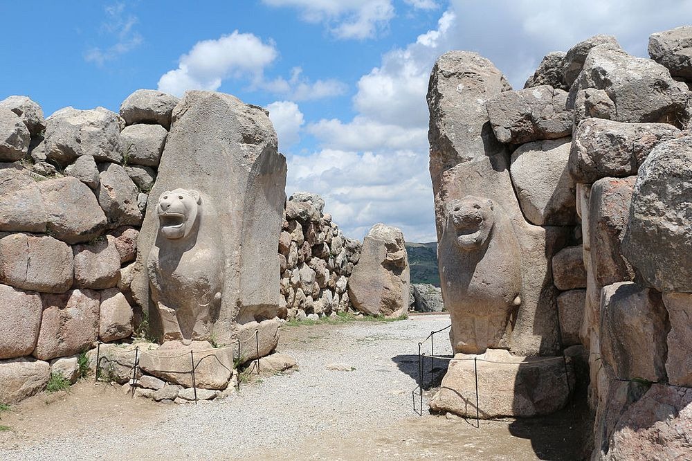
To the south lay an outer city of about 1 square km, with elaborate gateways decorated with reliefs showing warriors, lions, and sphinxes. Four temples were located here, each set around a porticoed courtyard, together with secular buildings and residential structures. Outside the walls are cemeteries, most of which contain cremation burials. Between 40,000 and 50,000 people is believed to have lived in the city at the peak.
hattusa-turkey-3
Lion Gate in Hattusa. Photo credit: Bernard Gagnon/Wikimedia
hattusa-turkey-2
King's Gate in Hattusa. Photo credit: turkisharchaeonews.net
hattusa-turkey-9
Sphinx Gate in Hattusa. Photo credit: Bernard Gagnon/Wikimedia
hattusa-turkey-15
A modern full-scale reconstruction of a section of the wall surrounding Hattusa. Photo credit: Maarten/Flickr
egyptian–hittite-peace-treaty-1
The Egyptian–Hittite peace treaty, on display at the Istanbul Archaeology Museum. It is believed to be the earliest example of any written international agreement of any kind. Photo credit: yasin turkoglu/Flickr
hattusa-turkey-6
Panoramic view of the Lower City of Hattusa. Photo credit: turkisharchaeonews.net
hattusa-turkey-7
Processional way of the Grand Temple complex, Hattusa. Photo credit: turkisharchaeonews.net
hattusa-turkey-8
Royal Citadel in Hattusa. Photo credit: turkisharchaeonews.net
hattusa-turkey-10
Entrance to a stone tunnel called the Yerkapı, in Hattusa. Photo credit: turkisharchaeonews.net
hattusa-turkey-12
Yerkapı in Hattusa. Photo credit: turkisharchaeonews.net
hattusa-turkey-11
The Yerkapi rampart at Hattusa. Photo credit: turkisharchaeonews.net
Sources: Wikipedia / Ancient Wisdom / UNESCO / Biblical Archaeology
Subscribe to our Newsletter and get articles like this delivered straight to your inbox